


October 2026
Overview
- What: The St. Paul Trail, which follows the Anatolian journeys of Saint Paul of Tarsus, is Turkey’s second‑longest cultural route after the Lycian Way [1].
- Where: It begins at the ancient city of Perge on the Antalya coast, crosses the area around Lake Eğirdir within Isparta’s borders, and extends to Yalvaç [1].
- Why it matters: By joining Roman stone roads with steep footpaths, it aligns a heritage of faith with a wild natural landscape on a single line [1].
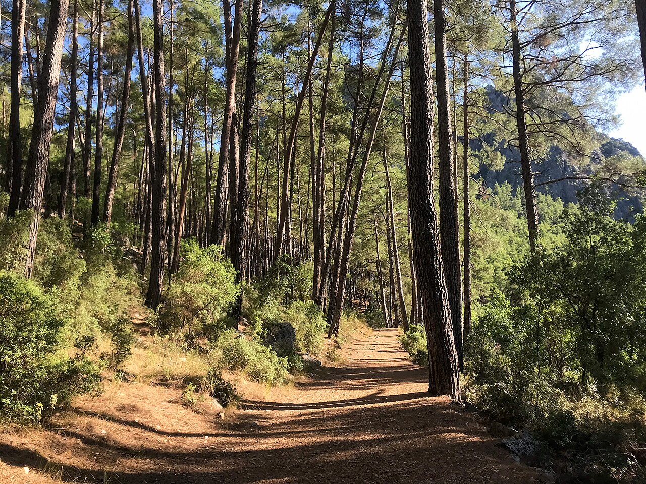
The St. Paul Trail is a comprehensive walking corridor that stretches from the Mediterranean shores to the steep slopes of the Taurus Mountains and the Lake Region [1]. This long line brings together early‑Christian historical memories with Anatolia’s rich rural geography [1]. Hikers can leave the noise of modern cities behind and progress step by step among Roman‑era ruins, forest tracks, and deep canyons [1].
The route offers more than a physical nature‑sport opportunity [1]; it also transmits a deep historical context and cultural accumulation to those who traverse it [1]. Trails that start at sea level gradually give way to high plateaus [1], then continue toward tranquil lake shores and sheer rocky valleys [1]. The clean scent of pine forests and the mountain panoramas combine along the way to create a unique environment for discovery [1].
Compared with the well‑known popular coastal walks, the natural atmosphere of this route is far more untouched [1]. It also features a considerably more rugged and uneven terrain [1]. Paths that run over the stone‑paved floors of ancient towns carry traces of a millennia‑old past into the present [1]. The adventure is designed for those who wish to walk at a relaxed pace without hurrying [1], allowing hikers to gain a much deeper understanding of Anatolian countryside and its ancient past [1].
Where is it?
The St. Paul Trail is an approximately 500‑km walking corridor that runs between the Mediterranean Region and the Lake Region in southwestern Turkey [1]. The main starting point of the route is the ancient city of Perge, located about 10 km east of Antalya’s city centre [4]. From there the trail proceeds northward through mountainous terrain in stages [1] and terminates in the district of Yalvaç, situated on the northeastern shore of Lake Eğirdir in Isparta Province [1].
Sources describe several alternative branches and entry points for the trail’s starting point [1]. One source mentions a second branch that begins at the Beşkonak site, the entrance to Köprülü Canyon National Park, 80 km northeast of Antalya [1]. This mountainous branch joins the main line coming from Perge at the ruins of the Roman town of Adada further north [1]. Another source states that after Perge the route can pass through the ancient city of Aspendos [2], from where it may be entered by following the bends of the Köprüçay River [2].
Natural conditions along the trail start at sea level and climb gradually to an altitude of 2 200 m [1]. The course also includes optional mountain summits that ambitious hikers can ascend, reaching up to roughly 2 800 m [1]. In terms of geography, deep‑valley passages such as Köprülü Canyon, Tazı Canyon and Yazılı Canyon shape the route’s impressive environmental fabric [2]. The trail later crosses the eastern slopes of Mount Barla [2], reaches the basin of Lake Eğirdir, and finally arrives at Yalvaç [2].
According to the stage plan prepared for the route, the walk begins with a 20–25 km section between Perge (Antalya) and Yazır [3]. The stretch from Yazır to Akçaalan is about 15–20 km [3]. The distance between Akçaalan and Mount Bozburun is roughly 20 km [3]. From Bozburun to Eğirdir the segment measures 25–30 km, Eğirdir to Barla 15–20 km, and Barla to Yalvaç another 15–20 km [3]. These stages allow walkers to transition from the mild Mediterranean climate to continental mountain steppe and finally to the cool lake basin [3].
History & Origins
The trail’s namesake, Saint Paul of Tarsus, is regarded as one of the most important figures who spread the nascent Christian faith across vast territories in its early centuries [1]. Jesus’ initial message in Judea and Jerusalem was first addressed only to the local Jewish communities [4]. Paul, however, carried this teaching to far larger audiences [5]; he brought it to the Jewish diaspora—communities that had migrated beyond their homeland—and also to people adhering to the traditional polytheistic Greek and Roman religions [5]. Paul never met the prophet Jesus in person [4] and his sermons were not based on a single written, standardized sacred text [4]. Consequently, he interpreted the message in a highly independent and free manner [4], adding his own rules of worship, conduct, and new instructions concerning women’s social life [4]. In doing so, he gave Christianity an institutional shape [4]. Scholars argue that had Paul not delivered these sermons, the Jewish revolt of 66 CE and the subsequent burning of Jerusalem might have erased Christianity from history entirely [4].
It is recorded that Paul set out to spread Christianity in AD 45 [1] and is believed to have traveled throughout Anatolia until his death in AD 67 [1]. The mountainous areas he crossed during what is considered the first missionary journey in “Little Asia” (the historic name for the Anatolian peninsula) constitute the core historical foundation of this walking route [1].
The official terminus, the ancient city of Pisidia Antiochia in Yalvaç, was one of the most important Roman centres where Paul preached and disseminated his faith [3]. This site should not be confused with the modern city of Antakya on the Syrian border; in antiquity many towns bore the name Antiochia, and the settlement in Yalvaç represents the Antiochia of the ancient Pisidia region [3]. Nevertheless, historical sources do not allow a precise, point‑by‑point reconstruction of Paul’s exact paths on contemporary maps [1].
The modern trail used by today’s hikers was designed by researcher Kate Clow—who also founded the Lycian Way—and her volunteer teams [1]. The route was developed to shift tourism activity toward Turkey’s interior and rural areas [4] and to introduce hikers to the challenging geographic conditions and travel culture of antiquity [4]. The trail was opened in 2008 by Kate Clow [4], [5] and aims to revive the historic link between the coastal city of Perge and the inland ancient Pisidia Antiochia [1].
Throughout history the corridor has witnessed not only the Roman period [6] but also a succession of other eras. The region’s soils contain layers of cultural heritage from the Hittites, the Phrygian civilization (known historically as the Frigians), Hellenistic kingdoms, the Roman Empire, the Byzantine Empire, the Seljuk State, and the Ottoman period [6]. In addition to offering a faith‑based historical journey, the St. Paul Trail connects the rural remnants of these deep civilisations [1], [6].
Architectural Form
The St. Paul Trail is not a single, modern road [1]; rather, it is a complex network formed by a variety of terrains and path types [1]. Original Roman stone‑paved roads appear throughout the course [1], interspersed with narrow goat tracks and earthen forest trails [1]. Certain flat and firm sections of the route also accommodate mountain‑bike use alongside walking [1].
In terms of physical character, the trail is far wilder, steeper, and more pristine than the Lycian Way [1]. Adventurers traverse deep canyon walls and mountain terrain bounded by sheer slopes [2]; the ground is intermittently rocky and involves steep climbs [1].
Numerous significant archaeological stops enrich the route both architecturally and visually [1]. The ruins of Perge at the trailhead, together with the ancient towns of Selge and Adada along the way, showcase Roman stone‑work at its full splendor [1], [2]. The ancient city of Aspendos and the historic bridges over the Köprüçay River are additional key elements that enhance the architectural fabric [2], [3]. The final destination, the Pisidia Antiochia site in Yalvaç, contains early Christian church remains and monastic traces [3].
Way‑finding infrastructure follows international long‑distance hiking standards [1]. Red‑white painted markings are applied to rocks and tree trunks along the route [1], and informational panels and direction signs are placed at junctions to guide walkers [1]. Thanks to these markings, the trail can be followed comfortably and safely even without a professional mountain guide [1].
Visiting Notes
Walking the entire ~500 km of the St. Paul Trail typically takes 27–30 days, depending on the hiker’s pace [1], [3]. To complete the long route within the planned timeframe, an average of 15–20 km per day is required [3]. Travelers with limited time may shorten the itinerary to suit their own schedule [1]; it is possible to reduce the total duration to 7–8 days by ending the walk at Eğirdir [1].
The most suitable seasons for walking, according to the sources, are spring and autumn [3]. In particular, the periods April–May and September–October offer the best conditions, avoiding extreme heat and freezing mountain cold [1], [3]. July and August are extremely hot in both the Mediterranean and Lake regions, so long treks are not recommended during those months [4]. The terrain is challenging for inexperienced hikers [2], [3]; therefore, prospective walkers should possess good physical fitness and endurance [2], [3].
Accommodation is often available in village houses or small family guesthouses along the route [1]. The town of Eğirdir serves as the most central hub for transport, logistics, and lodging [4]. However, in the long, desolate mountain sections where no settlement exists, camping becomes mandatory [4]. Numerous natural campgrounds suitable for tent pitching are found along the trail [4]; consequently, a sturdy tent, sleeping bag, sleeping mat, and sufficient dry provisions must be carried in the backpack [3].
Basic foodstuffs can be purchased in some rural villages along the way [3], but in uninhabited mountainous sections finding drinking water and food may become difficult [3]. Although red‑white trail markings are present, hikers are strongly advised to carry a topographic map and a GPS device [3]. A bilingual (Turkish‑English) mobile application called “Via Eurasia” can be downloaded from the App Store or Google Play to help follow the route [5].
Additional map options are available [5]. A 1:250 000 scale map prepared by Sabri Aydal can be obtained from the Antalya Museum [5]; it displays both the ancient coastal region of Pamphylia along the Antalya shoreline and the more northern, mountainous Lake Region of ancient Pisidia behind the Taurus Mountains [5]. For detailed logistical information, route conditions, and coordination of vehicle transfers, hikers can contact İbrahim, the operator of Lale Pension in Eğirdir [4], [5]. Finally, local public‑transport timetables are not detailed in the cited sources; therefore, travelers should verify current schedules with official authorities before departure.
References
- [1] Aziz Paul Yolu — https://turkiyeturizmansiklopedisi.com/aziz-paul-yolu
- [2] Türkiye’nin en uzun ikinci yürüyüş yolu Antalya’dan başlayıp Yalvaç’ta sona eriyor | ÖZYALVAÇ — https://www.ozyalvac.com/turkiyenin-en-uzun-ikinci-yuruyus-yolu-antalyadan-baslayip-yalvacta-sona-eriyor.html
- [3] Aziz Paul Yolu Kaç Km? Aziz Paul Yolu Etapları Nereden Başlar ve Biter, Kaç Gün Sürer? - Son Dakika Eğitim Haberleri — https://www.sabah.com.tr/egitim/aziz-paul-yolu-kac-km-aziz-paul-yolu-etaplari-nereden-baslar-ve-biter-kac-gun-surer-e1-7017630
- [4] St Paul Trail | Culture Routes Society — https://cultureroutesinturkey.com/st-paul-trail/
- [5] Aziz Paul Yolu | Kültür Rotaları Derneği — https://cultureroutesinturkey.com/tr/aziz-paul-yolu/
- [6] İNANÇ VE DOĞA TURİZMİNİN KESİŞTİĞİ NOKTA: AZİZ PAUL YOLU — Fatih Mehmet Berk (2014, DergiPark (Istanbul University)) — http://dergipark.gov.tr/jocress/issue/29464/315795
Konum
Harita: © OpenStreetMap katkıcıları. Haritada büyüt · Google Haritalar · Apple Haritalar
İşaret yaklaşık konumu gösterir; kesin konum için yerel kaynaklara bakın.
This article is compiled from scholarly monographs and official architectural inventories. Please verify site access conditions, visiting hours, and ongoing conservation status via official heritage authorities prior to visiting.