


October 2026
Overview
- What: A 46-stage long-distance hiking trail connecting ancient footpaths, caravan routes, and forests [1].
- Where: Stretching across the borders of Aydın and Muğla, particularly along the Bozburun and Datça peninsulas [2].
- Why it matters: Turkey’s longest hiking trail, linking ancient centers such as Knidos and Hydas [1, 2].
The Carian Trail is situated in the lands of southwestern Anatolia. This route weaves together stone-paved footpaths that have survived from antiquity to the present day [2]. The itinerary begins in the Çine district of the Aydın province. Proceeding from here, it links together all of Muğla’s peninsulas, coastal villages, and mountain passes [1].
The route winds across pine-forested mountain slopes. Alongside these, olive terraces and almond orchards—which occupy a vital place in the local economy—come into view [2]. Coves bordering the coastline soon give way to elevated hills, followed by old caravan routes and the ruins of ancient settlements [1, 2].
Hikers along the trail can witness ports left behind by the indigenous peoples of the ancient Caria region. At the same time, they can closely inspect the defensive fortresses bequeathed by these communities [2]. The Bozburun and Datça peninsulas stand out in particular, offering an exceptionally rich geography where the waters of the Mediterranean and the Aegean Sea converge [1, 4].
Where is it?
The Carian Trail is located in the southwestern corner of Turkey. The itinerary encompasses a vast geography spanning the provinces of Muğla and Aydın [2].
A minor classification discrepancy exists among sources regarding how many sections comprise the trail. According to some sources, the route consists of four main sections: the Bozburun Peninsula, the Datça Peninsula, the Gulf of Gökova, and Inland Caria [1]. In this fourfold system, the Muğla Environs is treated as an additional section, accompanied by an independent 11-kilometer Dalyan stretch [2]. Another source, however, states that the route is made up of five main sections [3]. In this second approach, the Muğla Environs is counted directly as the fifth main section. Consequently, both sources describe the exact same geographical routes; they merely differ in their method of categorizing the Muğla stage [1, 2, 3].
The Bozburun Peninsula section measures 141.2 kilometers in length and constitutes the official starting point of the trail [2]. This segment begins in İçmeler. It subsequently passes through Turunç, Kumlubük, Bayır, Taşlıca, Söğüt, Bozburun, Selimiye, and Orhaniye, finally concluding in the locality of Hisarönü [2]. The Bozburun Peninsula encompasses an area of approximately 300 square kilometers, with a distance of 18 kilometers to the island of Rhodes lying to its west [4]. There are 18 known fortified settlements situated across this peninsula, one of which is the ancient settlement of Hydas [4].
The Datça Peninsula section is a 240.7-kilometer course [2]. The route commences in Old Datça (Eski Datça). It continues through Hızırşah, Domuzçukuru, Mesudiye, Palamutbükü, Knidos, Karaköy, Kızlan, Emecik, Balıkaşıran, and Akçapınar, ultimately arriving at Akyaka [2]. The section between Balıkaşıran and Akyaka is distinguished by its flat terrain, permitting cycling alongside trekking [2].
The Gulf of Gökova section spans 139.2 kilometers, beginning in Akyaka and extending all the way to the ancient city of Pedasa in Bodrum [2]. The forest fires of summer 2021 impacted this region; due to the fires, certain parts of this section are noted as closed and seldom traversed by hikers [2].
The Inland Caria section measures 174.2 kilometers. Commencing from the shores of Lake Bafa, it ascends up to the 1,350-meter-high summit of Mount Latmos before terminating at the ancient city of Alinda in Karpuzlu [2]. The Muğla Environs section spans 108.5 kilometers and concludes at the ancient city of Stratonikeia [2].
History & Origins
The Carian Trail derives its name from the ancient Carian civilization, the early indigenous inhabitants of Anatolia [2]. Outdoor athletes had utilized the region’s paths through their own means even before the trail was officially opened [1]. However, the creation of a continuous hiking route uniting all these paths began with exploratory expeditions in 2009 [1, 2].
Researchers Yunus Özdemir, Altay Özcan, Volkan Demir, and Dean Livesley conducted fieldwork spanning four winters [1]. Step by step during these pioneering reconnaissance surveys, ancient roads, shepherd paths, ridge crests, and forest tracks across the region were mapped, thereby uniting scattered trails into a singular, cohesive itinerary [1, 2].
This independent initiative subsequently attained an institutional structure, transforming into an official development project spearheaded by the Muğla Chamber of Commerce and Industry (MUTSO) [1]. In 2012, financial support for the project was provided by the Southern Aegean Development Agency (GEKA) [1]. With the completion of infrastructure and waymarking efforts, the trail was officially opened to hikers in February 2013 [1, 2]. The route swiftly garnered international recognition, being chosen by National Geographic as one of the world’s 6 best adventure routes in 2021 [3].
The ancient settlements traversed by the trail, meanwhile, date back far earlier than modern history [2]. For example, the origins of the ancient city of Kaunos along the Dalyan section can be traced back to the 10th century BCE—roughly 3,000 years before the present day [2]. The city of Knidos, located at the westernmost tip of the Datça Peninsula, preserves rich remains hailing from the 4th century BCE [3].
Archaeological investigations conducted at the settlement of Hydas on the Bozburun Peninsula point to far earlier periods [4]. Surface surveys carried out in the region in 1998 and 2000 revealed that the settlement was continuously inhabited from the end of the Late Bronze Age (13th and 12th centuries BCE) through to Late Antiquity (between the 4th and 7th centuries CE) [4].
Ceramic sherds and archaeological artifacts recovered during the investigations suggest that the communities founding the city may have been migrants who had adopted Minoan-Mycenaean culture [4]. This culture denotes a shared way of life, art, and ceramic repertoire that spread across the Aegean basin during the Bronze Age through maritime trade and interaction between the Crete-centered Minoan civilization and the Mycenaean civilization of mainland Greece [4]. The founding period of mountainous defensive citadels such as Hydas is linked to these migrations; it is considered that such sheltered strongholds were constructed in response to the profound political turmoil, conflicts, and waves of migration that erupted across the Mediterranean basin toward the end of the Late Bronze Age [4].
Architectural Form
The Carian Trail is neither uniform nor monotonous. The itinerary integrates a rich array of architectural and natural features [2]. The trails consist of stone-paved ancient caravan routes, accompanied at intervals by narrow mule tracks, unpaved forest roads, and traditional village thoroughfares [2].
To ensure hikers can follow the trail safely without losing their way, waymarks adhering to the French Grande Randonnée standards were selected [2]. The French Grande Randonnée (GR for short) is an international trail-marking system devised for long-distance hiking routes. Under this standard, red and white stripes are painted on rocks and trees along the path; the direction and positioning of the stripes indicate to the hiker that they are on the correct path or signal upcoming turns [2]. In addition, directional wayfinding signposts are erected at critical intersections throughout the itinerary [1, 2].
Examining the overall length of the route reveals minor numerical divergences among sources arising from differing measurement methods—depending entirely on whether the calculation encompasses only the main arteries or includes intermediate linking trails. One Turkish source records the total length of the trail as approximately 800 kilometers [1]. However, in other sections of the same source and in another guidebook covering the subject, the length is cited as roughly 850 kilometers [1, 3]. The English source states the total length of the trail as approximately 820 kilometers (510 miles) [2]. All these figures demonstrate that, with its subsidiary paths and stage links, the route attains a vast total extent in the vicinity of 800 to 850 kilometers.
Ancient Fortresses and Hydas Architecture on the Bozburun Stage
The Bozburun Peninsula is home to settlements such as Amos, Syrna, Phoenix, Loryma, Hydas, and Castabus [2]. These settlements bear a fortified character [2]. A fortified settlement refers to a militarily protected and secured site encircled by thick defensive walls designed to withstand enemy assaults, sieges, and perils [2, 4].
One of the most prominent defensive complexes examined along this corridor is the ancient settlement of Hydas (also known as Hygassos) [4]. Spread over an area of approximately 3.5 hectares, Hydas is a steep hilltop settlement completely enclosed by high curtain walls [4].
From its foundational phase onwards, the city was fortified with Cyclopean walls—that is, reinforced and strengthened against any form of attack [4]. The term Cyclopean masonry denotes massive defensive walls constructed in antiquity without mortar by interlocking enormous, unworked polygonal stone blocks. These walls are composed of stones so colossal that legend held only the one-eyed giants, the Cyclopes, possessed the strength to lift them [4].
An acropolis stands at the highest point of the settlement [4]. An acropolis refers to a citadel typically erected atop a high, precipitous hill in ancient Greek and Anatolian cities. Unlike an ordinary defensive redoubt, an acropolis functioned both as an inner keep where the populace took refuge in times of peril and as the sanctuary housing the temples of the city’s patron deities, monuments, and the city’s most sacred precincts [4]. Overlooking and controlling the critical maritime trade route between the Eastern Mediterranean and the Aegean from its heights, the city also possessed a 1-hectare harbor along the coast [4].
The Datça Stage and the Ruins of Knidos
Throughout the Datça Peninsula, well-preserved sections of stone-paved roads surviving from antiquity can be clearly observed [3]. Advancing from the shore of Palamutbükü, the trail arrives at the ancient city of Knidos, established on the westernmost cape of the peninsula [2, 3].
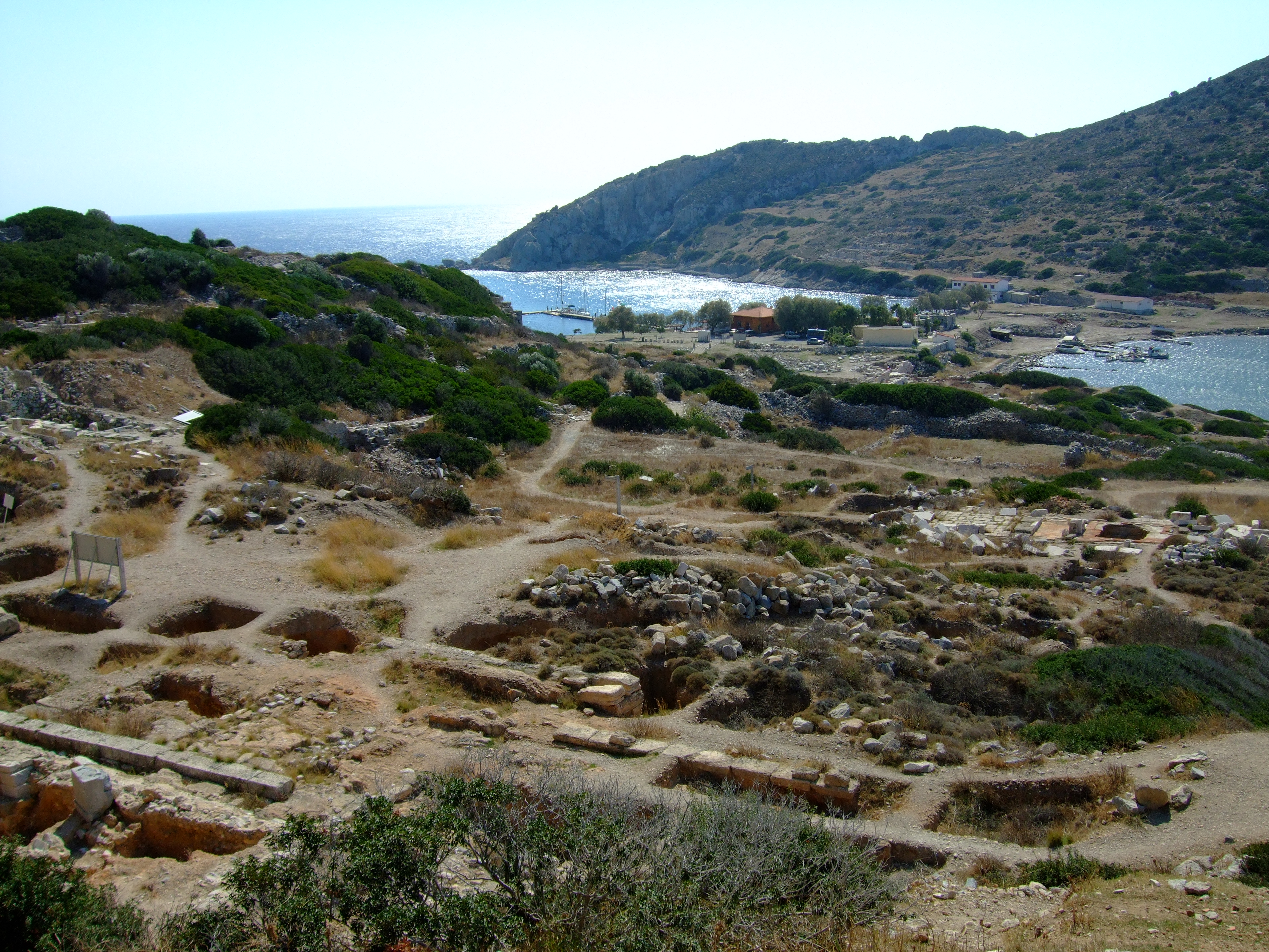
At Knidos lie the remains of an ancient theater built into a steep hillside, alongside the foundations of several temples and a historic lighthouse that guided mariners [1, 3]. These are far from the only ancient centers along the journey; the ruins of numerous ancient settlements—such as Idyma, Thera, Mobolla, Ceramos, Halicarnassus, and Pedasa—likewise line the route [2].
Visiting Notes
For those wishing to hike the Carian Trail, spring and autumn represent the most favorable seasons in terms of weather conditions [2, 3]. In the spring, March, April, and May should be preferred; for the autumn, September, October, and November are recommended [3]. One source notes that thanks to the mild southern climate, the winter months may also be utilized for hiking [2].
Hiking the trail during the summer months, however, entails very serious health risks [3]. In June, July, and August, regional temperatures can exceed 40 degrees Celsius even in the shade; furthermore, water sources along the terrain become exceedingly scarce or dry up entirely in summer [3]. The primary hazards hikers may encounter along the trail comprise severe weather conditions, dehydration, and the presence of wildlife [2].
Equipment selection plays a vital role in the preparation phase prior to setting out [3]. Waterproof trekking boots providing ankle support against sprains are strictly necessary. Hiking poles (trekking poles) are recommended to reduce strain on the knees during steep descents and ascents [3]. Backpack volume should be chosen according to accommodation style: a 50-liter backpack is suitable for those camping in tents, whereas a 40-liter pack is deemed sufficient for hikers staying in village guesthouses [3]. For those bivouacking or staying in tents overnight, carrying a sleeping bag rated down to 10 degrees Celsius and an insulating sleeping mat to block cold from the ground is recommended [3].
The trail contains deserted stretches where no water sources can be found for hours; for this reason, a minimum carrying capacity of at least 3 liters of water must be kept on hand in one’s pack at all times [3]. High-protection sunscreen (SPF 50+), a wide-brimmed hat, a windbreaker, rain gear, and a headlamp for night hiking should always have a place in the pack [3]. First-aid supplies for potential injuries, a power bank to recharge devices, and a GPS-enabled mobile phone constitute foundational safety essentials along the route [3]. Alongside physical trail waymarks on the path, GPS-enabled mobile mapping applications such as Wikiloc can also be utilized [3].
Selecting the appropriate stage provides ease for beginners. İçmeler, the trailhead of the Bozburun stage, or the settlement of Akyaka along the Gökova stage serve as highly suitable starting points [3]. Both locations can be easily reached by road via Dalaman Airport [3]. For less experienced hikers, shorter and more balanced itineraries such as Akyaka–Çetibeli, Palamutbükü–Knidos, or Kapıkırı–Yediler Monastery are recommended [3]. Current official sources should be consulted regarding visiting hours and museum admission fees; please confirm these with official authorities and the latest public announcements before setting out.
References
- [1] Karia Yolu - Vikipedi, https://tr.wikipedia.org/wiki/Karia_Yolu
- [2] Carian Trail - Wikipedia, https://en.wikipedia.org/wiki/Carian_Trail
- [3] Karia Yolu Rehberi: Yeni Başlayanlar İçin Her Şey | Kampp, https://www.kampp.in/blog/karia-yolu-rehberi-yeni-baslayanlar-icin-her-sey
- [4] Hydas; Bozburun Yarımadasında Müstahkem Bir Yerleşim Yeri — Mathias Benter (2010, Belleten), https://belleten.gov.tr/tam-metin-pdf/124/tur
Konum
Harita: © OpenStreetMap katkıcıları. Haritada büyüt · Google Haritalar · Apple Haritalar
İşaret yaklaşık konumu gösterir; kesin konum için yerel kaynaklara bakın.
This article is compiled from scholarly monographs and official architectural inventories. Please verify site access conditions, visiting hours, and ongoing conservation status via official heritage authorities prior to visiting.