


Publication Date: October 2026
Overview
- What: A rich trekking and cultural heritage area encompassing the ancient Lycian cities situated on the Teke Peninsula alongside historic Mediterranean coastal harbor settlements [2].
- Where: Stretching across the Teke Peninsula in southern Turkey [2]. This region extends across the ancient region of Caria to the west, ancient Pamphylia to the east, and along the city of Antalya established on the northwestern coast of the Gulf of Antalya [2].
- Why it matters: It hosted the earliest known democratic parliamentary system in history [2]. It is an internationally registered heritage area featuring unique monumental rock-cut tombs [2].
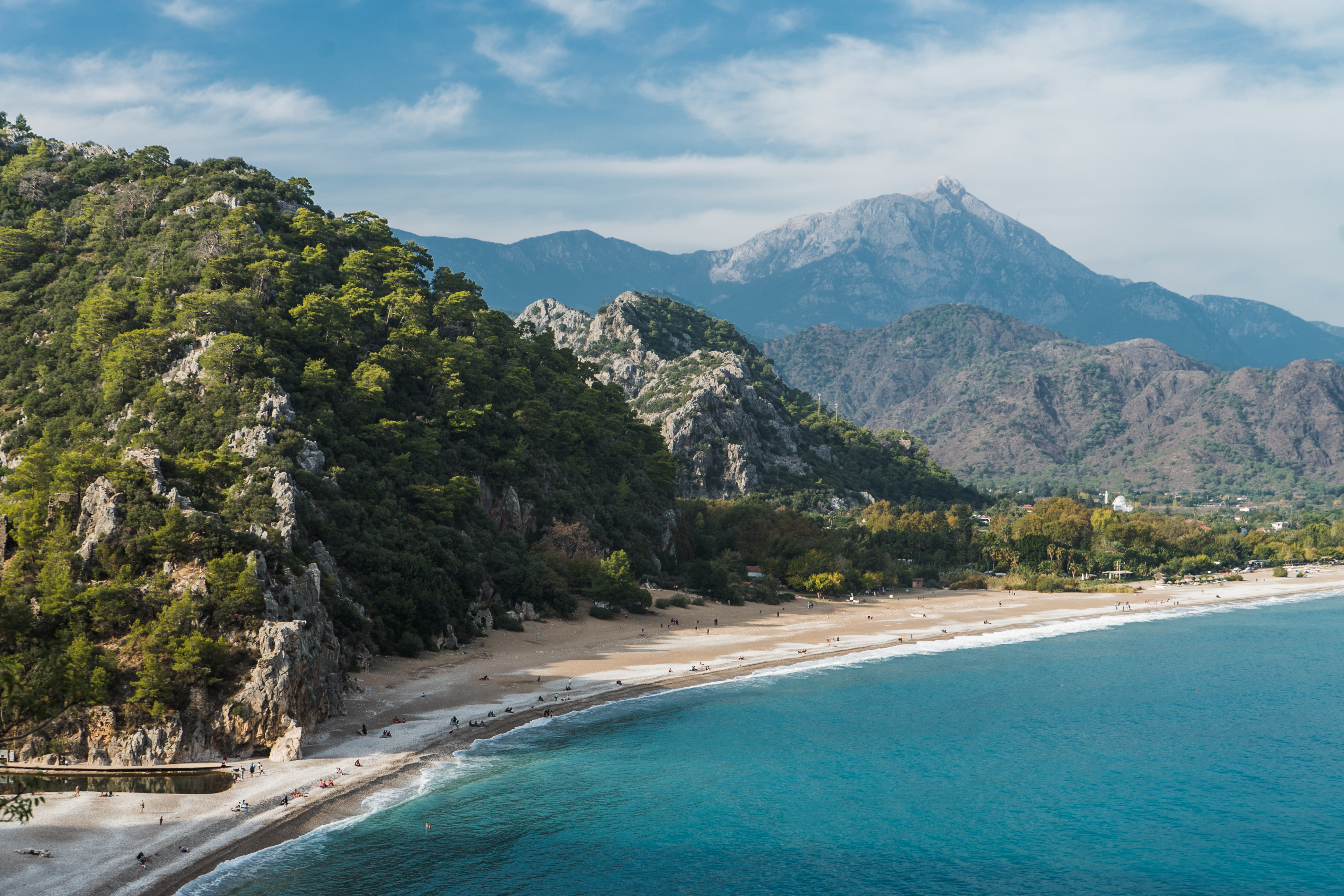
Stretching along the Mediterranean coastline, the Teke Peninsula harbors multilayered settlement traces that have endured from antiquity to the present day [2]. Sheer cliffs and steep hillsides rise along this extensive coastal ribbon [2]. These slopes conceal distinguished examples of thousands of years of stonemasonry [2]. Ancient settlements throughout the region were predominantly established on commanding heights overlooking the sea [2]. In this way, the settlements consistently maintained a close relationship with the maritime realm [2].
According to ancient written records, this geography served for millennia as the homeland of an ancient people known as the “Land of Light” [2]. Meanwhile, the Antalya plain, which intersects with Eastern Mediterranean trade networks, rises from the sea with sheer cliffs [1]. This plain is formed upon a rocky terrain [1]. Today, this historic corridor quietly carries the parliament buildings, monumental sarcophagi, and ancient harbor installations of the past into the present [2].
Where is it?
The ancient geographical region of Lycia encompasses a wide expanse across the Teke Peninsula on the southern coast of Turkey [2]. The boundaries of this historic peninsula are delineated by ancient regions [2]. The peninsula is encircled by the Mediterranean Sea to the south [2]. The ancient region of Caria lies along its western border [2]. The ancient region of Pamphylia extends along its eastern border [2]. The city of Antalya, which constitutes the eastern terminus of the region, was founded directly on the northwestern coast of the expansive Gulf of Antalya bearing its own name [1]. Through this setting, the city evolved into an important center on the northwestern shoreline of the gulf [1]. The urban settlement is situated on the flat terrain of the Antalya plain at an elevation of thirty meters [1]. This plateau descends to the sea via sheer rock precipices termed sea cliffs (falez) [1].
According to historical records, the geography of Lycia accommodated a large number of independent ancient cities and harbor settlements of varying sizes [2]. The capital city of Patara stands prominently at the center of this settlement network [2]. Alongside Patara, the cities of Xanthos, Pinara, Olympos, Myra, and Tlos also form the core of this network [2]. In subsequent periods, another strategic center was incorporated into these principal metropolises [2]. This center is the coastal harbor city of Phaselis on the Mediterranean shore [2].
In addition to these major centers, other well-known cities are situated across the region [2]. Among these settlements and harbor sites are Andriake and Sura [2]. Kyaneai, Limyra, and Theimussa also rank among the prominent settlements of the area [2]. Furthermore, the cities of Simena, Istlada, Trebenna, and Aperlae constitute part of this rich landscape [2].
The coastal strip of Fethiye and Göcek, situated along the western extension of this ancient geography, constitutes an open-air archive [4]. Telmessos rises in central Fethiye [4]. The ancient city of Tlos, regarded as an administrative hub, and Kaunos are situated within the boundaries of Seydikemer [4]. Kayaköy lies along the route between Fethiye and Ölüdeniz [4]. Paspatur is located in the town center of Fethiye [4]. Along the bays lie the remains of the Cleopatra Bath and Hamam Bay [4]. Known as a trekking route, the Lycian Way trail follows the coastline [4]. This route passes through the localities of Günlüklü, İnlice, and Göcek [4]. Ranked among seventy-eight tentative World Heritage sites across Turkey, the Ancient Cities of Lycian Civilization were inscribed on the tentative list in 2009 [3].
History & Origins
The earliest documented history of the Lycian landscape extends back to the second millennium BCE [2]. This era is recorded in Egyptian and Hittite written documents [2]. The Hittite King Šuppiluliuma explicitly stated in his official inscriptions that he conquered the “Lukka Lands” in the fourteenth century BCE [2]. A seafaring population recorded under the name of the Lukka people appears in the accounts of the Battle of Kadesh [2]. According to historians, this community’s name translates to the “Land of Light” [2]. The settlement history of the Antalya district is far older [1]. This chronology reaches back to the earliest eras when humanity first appeared on Anatolian soil [1].
The foundation of the city was carried out by King Attalos II of Pergamon [1]. The king was seeking a natural naval base and established the city upon the site of an earlier settlement [1]. The king took this measure because Side, the advanced port of the region, was under Roman control [1]. Consequently, he had to build a new city at the site of Antalya [1]. At the beginning of the first century BCE, the Roman Consul Servilius cleared the Pamphylian pirates from the region [1]. The consul subsequently fortified and strengthened the city’s castle walls [1]. In the middle of the first century BCE, the Lycian League—the earliest democratic federation in recorded history—was established with the participation of twenty-three city-states [2].
Operating as a bustling port during the Byzantine period, Antalya was subjected to Arab naval incursions from the seventh century onward [1]. These campaigns were led by naval commanders such as Fazl bin Qarin [1]. Captured by Suleiman Shah, the city changed hands between 1103 and 1120 [1]. During this period, the city passed under the administration of the Komnenos dynasty governing the Eastern Roman, or Byzantine, Empire [1]. Serving as a military base during the Crusades, the city was placed under the control of an Italian named Aldobrandini following the fall of Constantinople [1]. Sultan Ghiyath al-Din Kaykhusraw I incorporated the city into Seljuk territory in March 1207 [1]. The Sultan secured the support of the local Greek population during this conquest [1].
Mübariz al-Din Ertokuş, appointed as governor of the city, had the city walls restored [1]. The governor also appointed a kadi along with religious officials and commissioned a small mosque (mescid) [1]. During this era, the city acquired the honorific title Dar al-Thaghr [1]. In Islamic states, Dar al-Thaghr denotes a military and administrative frontier stronghold situated along borderlands to ensure security [1]. Although the city fell into the hands of the Cypriots in 1212, it was subsequently reconquered [1]. Sultan Izz al-Din Kaykawus restored the quays in January 1216 [1]. At the same time, the Sultan constructed a dockyard for the Seljuk fleet [1]. The region subsequently passed to the beys of the Tekeoğulları principality [1]. In the Republican era, Kayaköy was depopulated under the 1923 population exchange [4].
Architectural Form
Stonemasonry, Rock-Cut Tombs, and Vernacular Architecture
Lycian cities possess a distinctive architectural idiom with no counterpart across the Anatolian landscape [2]. These settlements exhibit high-quality stonework [2]. Stonemasons skillfully dressed limestone rock faces [2]. In doing so, they created monumental rock-cut tomb structures along the mountain slopes [2]. The Amyntas rock tombs, located within the ancient site of Telmessos in the center of Fethiye, represent monumental examples dating to the fourth century BCE [4].
The city of Kaunos near Göcek is laid out with its stepped theater, agora, and rock tombs [4]. The agora here served as an extensive public square in ancient cities where citizens congregated and commercial and civic affairs were conducted [4]. The city of Tlos in Seydikemer accommodates administrative structures [4]. Kayaköy in Fethiye features abandoned masonry Greek residences and churches [4]. Masonry houses in this settlement are buildings constructed from durable massive materials bonded with mortar, such as stone or brick, rather than timber [4].
Patara Parliament Building and the Representation System
In the city of Patara, the capital of the Lycian League, rises the Parliament Building (Bouleuterion), considered the most significant political monument of classical antiquity [2]. This administrative assembly hall served as the gathering place for the council members of the twenty-three federated cities [2]. Members were elected and dispatched here in proportion to the size of their respective cities [2]. Patara, Xanthos, Pinara, Olympos, Myra, Tlos, and Phaselis each held three voting rights [2]. Other cities possessed two votes or a single vote in accordance with their population and importance [2].
The representative assembly was charged with specific civic duties [2]. These responsibilities encompassed financial administration and the adjudication of legal disputes [2]. The council was likewise responsible for managing economic affairs and overseeing religious matters [2]. Grounded in the principle of proportional representation, this unique parliamentary structure served as a direct inspiration for contemporary democratic systems of governance [2].
Harbor Fortifications, Inscriptions, and Motifs
Inscriptions associated with ancestor worship appear on the monumental tombs [2]. Ancestor worship designates the belief system involving veneration of the spirits of deceased forebears, faith in their guardianship, and the perpetuation of their memory through ritual practices [2]. These inscriptions reflect the kinship structures and spiritual beliefs of the Lycians [2]. Having carved inscriptions in their own indigenous alphabet, the Lycian language has been partially deciphered today through systematic archaeological excavations [2].
In the bays of Göcek, there is the famous fish motif rendered directly onto the rock surface [4]. This artwork was created by the painter Bedri Rahmi Eyüboğlu [4]. In central Antalya, the Seljuk city walls, renovated quays, and dockyard structures rise atop thirty-meter-high sheer sea cliffs [1]. The submerged walls of Roman baths extend along the coves [4]. The Paspatur quarter of Fethiye illustrates commercial vernacular architecture of the Ottoman era [4].
Visiting Notes
The ancient cities across the region are protected as first-degree archaeological conservation sites under Law No. 2863 [2]. The sites also fall within designated environmental protection zones [2]. These areas are under the jurisdiction of the Ministry of Environment and Forestry’s Authority for the Protection of Special Areas [2]. Consequently, visitors must refrain from touching walls within the archaeological sites [4]. Stone pavements must not be damaged, and littering across the sites is strictly prohibited [4]. Historical records indicate that severe penalties are imposed on individuals who damage ancient paving stones or deface ruins [4].
Hikers must follow the official Lycian Way trail markings along the Günlüklü, İnlice, and Göcek route [4]. In accordance with nature conservation regulations, lighting campfires along the trail is strictly forbidden [4]. When touring the rock tombs of Telmessos and Kaunos, caution should be exercised regarding slippery footing [4]. Visitors must not enter the interior spaces of the burial chambers [4]. At the ancient site of Tlos, precautions should be taken against direct sun exposure in open areas [4]. Active excavation sectors must never be approached [4].
Climbing the masonry structures in Kayaköy is prohibited [4]. Open flames may not be lit inside the enclosed sections of the abandoned churches [4]. Flying unmanned aerial vehicles (drones) in the region is subject to official permission [4]. Photography is restricted inside certain shops in the Paspatur bazaar [4]. Climbing the walls of the Cleopatra Bath is prohibited [4].
Vessels may only be moored to areas delimited by mooring buoys (tonoz) [4]. In maritime practice, a tonoz (deadweight mooring) is a heavy concrete block or ballast system placed on the seabed allowing boats to moor securely without dropping anchor onto the seabed or shoreline [4]. This restriction is enforced to protect the seabed and submerged archaeological remains [4]. When snorkeling, attention must be paid to coastal rock formations, and submerged historical artifacts must under no circumstances be displaced or removed [4]. For the rock painting in Bedri Rahmi Bay, guiding regulations must be observed [4].
Current opening hours, admission fees, and transportation details for all these historic cities and hiking routes should be verified through official channels; please consult official sources for up-to-date fees and operating schedules.
References
- [1] ANTALYA - TDV İslâm Ansiklopedisi
ADRES: https://islamansiklopedisi.org.tr/antalya - [2] Ancient Cities of Lycian Civilization - UNESCO World Heritage Centre
ADRES: https://whc.unesco.org/en/tentativelists/5408/ - [3] Icomos Türkiye
ADRES: https://www.icomos.org.tr/?Sayfa=Turkiyedunyamirasigecicilistesi&dil=en - [4] Skopea Inn Exclusive Hotel
ADRES: https://www.kulturportali.gov.tr/turkiye/mugla/gezilecekyer/kayakoy
Konum
Harita: © OpenStreetMap katkıcıları. Haritada büyüt · Google Haritalar · Apple Haritalar
İşaret yaklaşık konumu gösterir; kesin konum için yerel kaynaklara bakın.
This article is compiled from scholarly monographs and official architectural inventories. Please verify site access conditions, visiting hours, and ongoing conservation status via official heritage authorities prior to visiting.