

Summary
- What is it? A monumental waqf complex constructed between the late 12th and early 13th centuries (approx. 1192–1202) by Ahlatlı Architect Ebü’n-Nemâ b. Mufaddal on behalf of Saltuklu ruler Melike Mama Hatun, comprising a circular encircling wall mausoleum with niches, segmental dome, caravanserai, hammam, and mosque [1], [2].
- Where is it? Located in the central district of Tercan, Erzincan, along the historical Silk Road route connecting Erzurum–Erzincan–Sivas [1], [3].
- Why is it significant? The 13.50-meter-diameter circular encircling wall and its interior surface with thirteen pointed-arched niches/hazire arrangements constitute a unique plan schema absent in global and Islamic mausoleum architecture [1], [4].
- Architectural Typology: A two-story, octagonal-based, segmental cylindrical body with cross-vaulted mummy chamber, crowned by a segmented conical cupola [1], [2].
Historical Context and Construction Process
During the second half of the 12th century, the Saltuklu Beylik governed Eastern Anatolia as a powerful Turkic-Islamic state centered in Erzurum [1], [2]. Melike Mama Hatun, who assumed leadership in 1191 as daughter of II. İzzeddin Saltuk, became one of the rare female rulers in medieval Islamic history to mint currency and deliver sermons [1], [4]. She commissioned this monumental complex to transform Tercan—located on the western frontier of her realm—into a thriving caravanserai hub and establish her eternal resting place [1], [2].
Construction dates between the final quarter of the 12th century and early years of the 13th (approx. 1192–1202) [1], [2]. The western portal inscription explicitly identifies Ebü’n-Nemâ b. Mufaddal as the architect, referencing “the work of Ebü’n-Nemâ son of Mufaddal from Ahlat” in Arabic cursive script [1], [2]. As a master of Ahlat’s stone-carving tradition and monumental architecture, Ebü’n-Nemâ synthesized the classical mausoleum form with a circular fortress/hazire courtyard to create an unprecedented architectural composition [1], [4].
The complex comprises: (1) a 51×51-meter caravanserai (ribat), (2) hammam, (3) mosque, and (4) the historic Kötür Bridge with eight-arched access to the caravanserai, forming an expansive waystation waqf [1], [3].
Architectural Plan and Spatial Composition
The central mausoleum complex consists of two primary architectural masses: the outer circular encircling wall and the segmented monumental tomb rising at its geometric center [1], [2].
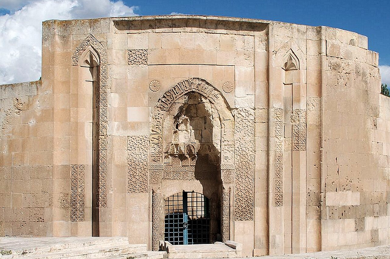
The exterior wall—a 13.50-meter-diameter, 2.50-meter-thick monolithic cut stone cylinder—reaches approximately 3.50 meters in height [1], [2]. Its interior surface is animated by thirteen pointed-arched niches creating dynamic plasticity [1], [2]. The first niche to the left of the entrance contains a three-part muqarnas corbel, fountain motif, and grapevine relief [1]. Six other niches house sarcophagi belonging to Mama Hatun’s family members, transforming the space into an open-air dynastic necropolis [1], [2].
The central mausoleum, elevated independently within the circular courtyard, rests on an octagonal base [1], [2]. Its cylindrical body is segmented with semicircular profiles (segmented body), creating a highly dynamic silhouette [1], [4]. This segmented body culminates in a segmented pyramidal/conical stone cupola [1], [2].
The mausoleum follows the classical two-tiered structure: the ground floor houses the mummy chamber (crypt) with a cross-vaulted ceiling spanning four cardinal directions [1], [2]. The upper level functions as a memorial visitation space, enclosed by a dome directly above the circular interior [1], [4].
Stone Decoration, Ornamentation, and Inscriptions
Fine yellowish and light-brown cut tufa stone from the region was used in construction, with stonework achieving sculptural refinement on façades [1], [2].
The most elaborate decorative focus is the monumental portal on the western face of the circular wall [1], [2]. This protruding prismatic mass rises above the façade surface [1]. Geometric zencirek patterns, knot motifs, eight-pointed stars, and palmette sequences are deeply carved into the border framing the entrance niche [1], [2]. The central keystone of the portal arch bears the Surah Ikhlas in large Kufic script [1]. Star reliefs on the capitals of the supporting columns feature the names of Allah, Muhammad, and the four caliphs (Abu Bakr, Umar, Osman, Ali) in large sülüs script [1], [2].
The grapevine and vine leaf motifs within the niche of the surrounding wall represent some of the most vivid expressions of fertility and paradise imagery in Turkic-Islamic stone art [1], [4]. The segmented body and cupola base of the central mausoleum, adorned with muqarnas friezes, create mesmerizing plastic dynamism through shifting shadow-light interplay throughout the day [1], [2].
Waqf System and Social Function
Beyond its dynastic tomb function, Mama Hatun Complex served as a major waystation waqf ensuring security and logistics along the historical trade routes connecting Erzurum, Erzincan, and Trabzon [1], [3]. To finance the caravanserai, hammam, and imaret services, Mama Hatun endowed Tercan’s surrounding pastures, villages, and mills to waqf [1], [2].
The 51×51-meter caravanserai (ribat) featured a central courtyard with stables, guest chambers, and storage facilities enclosed by winterized vaulted structures [1], [2]. Travelers and merchants could stay free of charge for three days, receive meals, and care for their animals [1], [3]. The hammam addressed hygiene needs for both travelers and local populations [1], [2]. Thus, this waqf complex became a pinnacle example of social statehood and waqf civilization in medieval Anatolia [1], [4].
Restoration History and Conservation Status
Exposure to winter conditions, frost, earthquakes, and erosion over centuries has caused superficial weathering, particularly at the cupola joints and surrounding wall stones [1], [2]. The original mosque within the complex was demolished and replaced by a new mosque in later centuries [1].
Designated as a first-degree monumental heritage site during the Republic era, the complex underwent major restorations by the General Directorate of Foundations in the 1960s, 1990s, and most recently between 2018–2021 [1], [3]. Recent restoration work included hydrolic lime injection to stabilize cracked stones in the circular wall, faithful restoration of eroded elements on the portal, reinforcement of caravanserai vaults, and completion of surrounding landscaping [1], [3]. The site remains open for visits in its original grandeur [1], [2].
Frequently Asked Questions
What is Mama Hatun Mausoleum’s most significant architectural feature?
The 13.50-meter-diameter circular encircling wall with thirteen pointed-arched niches/hazire arrangements constitutes a unique design absent from any other mausoleum in Anatolia or globally [1], [4].
Who commissioned the complex and who was its architect?
Commissioned by Saltuklu ruler Melike Mama Hatun, the complex was constructed between 1192–1202 by Ahlatlı Architect Ebü’n-Nemâ b. Mufaddal [1], [2].
Who was Mama Hatun?
Daughter of II. İzzeddin Saltuk, she ruled the Saltuklu state de facto from 1191–1201, minting currency in her name as a powerful female Turkic ruler [1], [4].
What structures compose the complex?
The complex comprises: (1) a circular encircling wall mausoleum, (2) a massive 51×51-meter caravanserai (ribat), (3) hammam, (4) mosque, and (5) historic Kötür Bridge connecting to the caravanserai [1], [3].
References
- [1] Ara Altun & Abdülkerim Özaydın, “Mama Hatun Complex,” TDV İslâm Ansiklopedisi, Vol. 27, pp. 548–550, Ankara 2003 — https://islamansiklopedisi.org.tr/mama-hatun-kulliyesi
- [2] Albert Gabriel, “Monuments Turcs d’Anatolie,” Vol. II, pp. 165–170, Paris 1934 — https://erzincan.ktb.gov.tr
- [3] T.C. Erzincan Valiliği, “Tercan Mama Hatun Tomb and Complex Cultural Inventory,” Erzincan — https://www.erzincan.gov.tr/mamahatun-turbesi
- [4] Oktay Aslanapa, “Turkish Art,” pp. 160–161, Remzi Kitabevi, İstanbul 1997 — https://kulturportali.gov.tr
Konum
Harita: © OpenStreetMap katkıcıları. Haritada büyüt · Google Haritalar · Apple Haritalar
İşaret yaklaşık konumu gösterir; kesin konum için yerel kaynaklara bakın.
This article is compiled from scholarly monographs and official architectural inventories. Please verify site access conditions, visiting hours, and ongoing conservation status via official heritage authorities prior to visiting.
_1190-1200_CE.jpg)